


Tropical depression off Southern Luzon to enter PAR Sunday
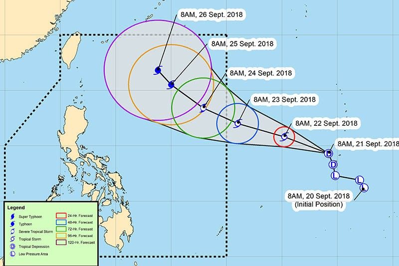
MANILA, Philippines — A low pressure area outside the Philippine area of responsibility developed into a tropical depression Friday morning, state weather bureau PAGASA said. The tropical depression is expected to enter PAR by Sunday morning as a tropical storm. As of 10 a.m., the tropical depression—with maximum sustained winds of 55 kilometers per hour near the center and gust of 65 kilometers per hour—was last seen 2,160 kilometers east of Southern Luzon. “The tropical depression is still far away to have any effect in the country,” the state weather bureau said. Forecast positions and intensitiesSaturday morning: 1,735 kilometers east of Virac, Catanduanes (outside PAR) as tropical stormSunday morning: 1,555 kilometers east of Infanta, Quezon (outside PAR) as tropical stormMonday morning: 1,190 kilometers east of Aparri, Cagayan as severe tropical stormTuesday morning: 835 kilometers east of Basco, Batanes as typhoonWednesday morning: 645 kilometers east of Basco, Batanes as typhoon— Gaea Katreena Cabico
Source: Philippine Star September 21, 2018 05:37 UTC

